|
Sherkin
Island and the other Islands
of Roaringwater Bay
Every
island has its own character and distinctive flora and vegetation.
In this section we outline features of each island or group
for the benefit of the visitor.
Map
of Roaringwater Bay
Sherkin
Island
Map
of Sherkin Island
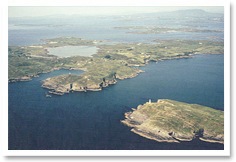
Sherkin
has all the habitats present in the islands. It also has the
largest flora. Obviously it received more attention from Marine
Station botanists. It is more sheltered than the other islands
and exhibits a wide range of topography and land use.
Sherkin,
10 minutes from Baltimore by ferry, is easily explored by
the visitor. A tarmac road leads from the ferry landing-stage
at Abbey Strand to the south western end of the island. Another
road runs from the Abbey, past the Castle, the hotel and the
Jolly Roger, to The Dock at the north-eastern corner of the
island. Just to the west of Kinish Harbour the main east-west
road forks and another good road runs to Cow and Silver Strands,
with their fine sands and safe bathing. A network of footpaths
and tracks enable the visitor to reach the western coast,
Horseshoe Harbour and the lighthouse, but much of Slievemore,
including the bay of Foardree, and the peninsula of Farranacoush
are difficult of access.
The island
rises to 112 m on its hilly backbone, Slievemore. The walk
up - the summit is best approached from the south side - provides
an opportunity to see interesting heathland plants and the
high ground affords magnificent views across to Cape Clear
and is a good place to watch for whales, porpoises and dolphins.
In a valley on the north side lies Lough Ordree, fringed by
an extensive reedswamp and marshes. These contain Bulrushes,
the imposing Royal Fern and a rich sedge flora, which includes
Bottle, Cyperus, Greater Pond and Greater Tussock sedges.
Care should be taken for it is a deep and dangerous lake and
drownings do occur.
Much of
the island is rough grazing and heathland, with some woodland
and scrub developing. The main grazing animals on the island
today are cattle; there are no rabbits. The settlement at
the eastern end has most of the island's facilities and the
majority of the inhabitants live between the harbour and Trabawn.
The population stands at about 100, which increases substantially
during the summer months.
The coastal
heathlands are best seen at the beautiful bays of Horseshoe
Harbour and Trabawn. Horseshoe Harbour has several rare clovers
and other plants, while Trabawn has a range of vegetation
that includes very fine coastal heathland. The marsh at Trabawn
has many wetland plants and the adjacent strand and low cliffs
are species-rich. The low sward of the promontory on the northern
side of the bay is a carpet of miniature flowers in summer.
The pastures on the south-eastern side of the bay are bright
with orchids and other grassland flowers.
The south
side of Kinish Harbour has saltmarsh communities and the only
substantial stand of woodland in the islands. Two climbing
plants on walls are a feature: the vine-like Hop and the coastal
subspecies of Hedge Bindweed, with pink-striped trumpet flowers.
A relatively short walk along the northern branch of the road
takes one to Cow and Silver Strands. Here the grassland on
blown sand is a mass of orchids and other flowers in June.
In late August, Autumn Lady's-tresses flowers freely by rock
outcrops above the strand. Hop Trefoil grows on a wall near
Cow Strand at its main locality in the islands. Another distinctive
plant here is Sea Radish, abundant on the sandy roadside.
The stone
walls and sheltered lanes of Sherkin have a varied flora,
especially of ferns. The base of walls along the road to the
Dock is a good place to see a range of ferns, especially Hay-scented
Buckler-fern, Hard Fern and Soft Shield-fern. The settlement
at the eastern end has many interesting plants associated
with the long human occupation of the island. The Castle has
a rich flora of weeds and ancient medicinal plants, including
the stately Elecampane and Alexanders. By nearby cottages
grow Hemlock and Wormwood. Many of the cottages have neat
and attractive gardens, and the Fuchsia hedges, covered with
thousands of pendulous red flowers, are magnificent all through
the summer.
More
on Sherkin Island
Top
of page
Cape
Clear Island
The largest
and most hilly (up to 159 m) of the islands, Cape Clear has
substantial areas of higher ground, much of it covered by
heathland and farmland. The 120 or so inhabitants earn their
living by farming, fishing and tourism. Cape Clear is Irish-speaking
and a centre for the study of the Irish language and traditional
culture. The island has a network of tarmac roads with a surprising
amount of motor traffic.
Trees
are few on this exposed island, but there are some shelter
belts and many hedges. Pastures are grazed by cattle, and
a few goats, and there is a large population of rabbits. There
are extensive haymeadows on the island, but all appear to
have been improved by reseeding and the application of fertilizers.
Wetlands
are concentrated at the western end. As well as Lough Errul,
the major water body in the islands, there are West Bog, Central
Bog (drained in the 1960s) and East Bog. East Bog is the largest
and is dominated by reed swamp. Smaller communities of damp-
or wet-loving plants, including luxuriant ferns, are found
along small streams and runnels. Drystone walls provide another
fern habitat, notably for the lime- and frost-intolerant Lanceolate
Spleenwort and Hay-scented Buckler-fern.
Lough
Errul has a relatively poor flora apart from large populations
of two plants. The southern, and to a lesser extent the eastern,
margin is coloured pink in late summer by a dense stand of
Amphibious Bistort. Much of the stony bottom of the lake is
covered by a dense mat of Shoreweed, only seen when the water
level is lower as in the dry summer of 1995. The waysides
and Bracken-covered banks between Lough Errul and South Harbour
have a number of interesting plants, including Marsh Mallow
and Red Campion - Cape Clear is the only island in the Bay
where the latter occurs.
Cape Clear
is mostly bounded with steep cliffs and precipitous rocks,
so sand and shingle strands are poorly developed, as is saltmarsh.
The steep slopes above South Harbour have some of the best
dry coastal heathland in the islands; Hairy Bird's-foot Trefoil
grows here in the site where it was first discovered in Ireland
by J. Emmet O'Donovan and others in 1953.
Hardly
any tillage remains. Crops of Turnip Rape at the western end
of the island are rich in weeds. One field in 1992 had both
a golden carpet of Corn Marigold and a few plants of the very
rare Henbit Dead-nettle. However, in 1993-95 it was under
grass. Records held at the Bird Observatory show that Lesser
Snapdragon has come up repeatedly over 30 years in fields
near South Harbour. Note that access can be difficult and
permission should always be sought from landowners.
Recent
building above South Harbour has created open disturbed habitats
suitable for weeds. Sowing of commercial wildflower seed in
1995 has confused the picture, but several arable weeds have
come up in this area in recent years, presumably from buried
seed. North Harbour is a good place to look for weeds and
one rare plant at least, Bird's-foot Clover, survives amongst
the cobbles of the harbour moles. Musk Storksbill is often
frequent on waysides near the Bird Observatory, and can be
found on walls right across to South Harbour. With it is the
diminutive Sea Storksbill, a speciality of the Cape Clear
flora. The top of the wall outside the Youth Hostel at South
Harbour is a good place to see these two storksbills!
More
on Cape Clear
Top
of page
The Calf
Islands
West,
Middle and East Calf form a chain in the very centre of Roaringwater
Bay. From higher ground on Cape Clear on a sunny day they
are a striking sight, dark patches in a blue sea and remarkably
low-lying. West Calf rises to 22 m, Middle Calf to just 11
m and East Calf to 19 m. They are consequently exposed and
treeless. Nevertheless, all were settled and the last inhabitants
left only in the 1940s. Today, cattle are still grazed amongst
the ruins of the former farms. Hares occur on all three islands.
West Calf
is less grazed and is dominated by rank grassland. West and
Middle Calf have small areas of blown sand and Middle and
East Calf have shingle strands. Middle Calf has marshy ground
and a series of broad shingle strands at the western end.
The strands have a classic seaside flora, including Yellow-horned
Poppy, Sea Spurge, Sea Kale and Sea-holly. East Calf has more
habitat diversity, with heathland on higher ground (including
a famous locality for Spotted Rockrose), grassland over blown
sand and a small lough surrounded by marshy ground rich in
plants. The lough has yielded numerous records of aquatic
plants, including pondweeds and water-crowfoots.
Top
of page
The Carthy
Islands
The Carthys
are four low, rocky islands, very exposed and home to large
numbers of sea-birds, mainly gulls. These damage the vegetation
by trampling and over-enrichment by their droppings. North
Island has in the past been grazed by sheep. There is some
shingle and coastal grassland, but the flora is mostly plants
of the salt-spray zone and common weeds, including stands
of Hogweed and thistles. The only plant of note is Sea Radish,
which is abundant.
Top
of page
Goat
& Little Goat Islands
Goat,
surrounded by rugged cliffs, rises steeply to 32 m. The vegetation
is heathland dominated by rank grasses and some gorse. The
few plants recorded grow mostly on rock outcrops. There are
traces of a former farm, around which the soil is deeper and
presumably improved.
Little
Goat is an adjacent sea-stack with very few flowering plants
recorded. Both Goat and Little Goat are difficult to reach
and to explore, and of more interest for their birds than
their plants!
Top
of page
Long
Island
This is
the largest island after Cape Clear and Sherkin. However,
it is low-lying, with a maximum elevation of 29 m. There are
a few permanent inhabitants, most of whom live on the northern
side of the central part of the island. A good track runs
for much of the length of the island, but fades into a path
at the eastern end. The island is almost treeless. Heathland
dominates, with some areas of pasture. There is boggy ground,
with peaty pools that support a rich aquatic flora. Sheep
and cattle graze enclosed areas of heathland at the eastern
end of the island.
Stone
walls, especially along tracks, are rich in plants and in
one place at least, the rare fern, Lanceolate Spleenwort.
A wall at the settlement towards the western end has a thriving
population of the rare geranium Little Robin, known elsewhere
in Ireland only from Cork City. Several of the gardens on
Long have interesting collections of plants, some of which
have escaped. These include medicinal plants and herbs, such
as mints, Horse-radish and Comfrey.
The shingle
and coastal grassland towards the western end has a rich flora
including Little Robin, Yellow Horned-poppy and various uncommon
weeds.
Top
of page
Castle
Island
Castle,
rising to 36 m, is dominated by gorse scrub and bracken, with
occasional willows and improved pastures grazed by sheep.
There are ruined settlements at the eastern end and to the
west of the tower (ruins of an O'Mahony castle). Wayside weeds,
such as Good King Henry, Small Nettle and Musk Storksbill
are relics of former human occupation and disturbance. A shingle
strand south of the castle has a number of seaside plants,
including a low-growing variant of Herb Robert.
The cliffs
towards the eastern end are dissected by ivy-covered gullies
and have a lush vegetation of tall plants, such as Royal Fern
and Irish Spurge. Heathland occurs on the rising ground at
the western end of the island.
Top
of page
Horse
Island
Horse
is a low-lying island with a maximum elevation of 37 m. A
stony track leads from the old village at the eastern end
to the landing stage at the north-western corner. Much of
the island is overgrown by scrub and bracken (the home, it
should be noted, of numerous ticks), but the track is a convenient
way to reach the most interesting habitats.
The soil
of much of the island is clayey, damp and frequently water-logged.
Willows grow well in the damp soil and are a feature of Horse,
with several species and hybrids apparently introduced. Recently
other trees have been planted, including Aspen and Birch,
together with garden plants such as Tree Mallow and Pampas
Grass. Sheep graze parts of the island, but goats were removed
in 1994.
There
are also some fine coastal grasslands dominated by blown sand
at the western end. At the eastern end, rock outcrops alternate
with some of the most interesting grasslands in the islands.
Copper and small amounts of other minerals used to be mined
in this area and the overgrown spoil heaps and adjacent grassland
carry a special flora that includes at least two colonies
of Common Broomrape, and Deptford Pink at its only known Irish
station. Nearby in 1995 grew the largest group of Great Mullein
to be seen in the islands. These imposing plants, up to 2
m tall, dominated an old trackway.
A large
house at the western end of Horse is lived in from time to
time and one of the old dwellings of the eastern settlement
has been refurbished. At least three more houses are being
erected at the present time, presumably as holiday cottages.
This has not apparently damaged the most important habitats
and, indeed, has allowed dormant weed seed to germinate, including
that of some of the rarer weeds like Purple Ramping-fumitory
and Sharp-leaved Fluellen.
Top
of page
The Skeams
These
two islands are very different in character. Skeam West is
for the most part a west-east valley flanked by rocky, heathy
ground. The valley has lush grassland. At the western end
there is a shingle beach. The small settlement at the eastern
end has been restored as a holiday property but remains deserted.
Knotted Hedge-parsley grows here, together with other weeds
and plants of disturbed ground. The church by the settlement
is said to date from the 9th Century. Sheep are grazed from
time to time on this treeless island.
Skeam
East has a more varied topography including an impressive
rock arch on the western coast. Heathland dominates the higher,
rocky ground and pasture, which is grazed by goats and cattle,
covers the lower, damper, sometimes marshy ground. A few planted
conifers persist, but the island is mostly treeless. The ruins
of a small settlement by the strand at the eastern end have
an interesting weed flora. The strand is a traditional landing
place for livestock and nearby grow Small Nettle, Wormwood
and other weeds of local distribution in the islands. Pellitory-of-the-Wall,
growing on the ruins, is a probably relic of former medicinal
use by the inhabitants.
Top
of page
Heir
Island
Apart
from Sherkin and Cape Clear, Heir has the largest number of
flowering plants and ferns in the islands. The island is mostly
low-lying, with the highest ground (up to 92 m) at the western
end. The island has around 30 inhabitants. A road runs from
the East Pier almost the length of the island, becoming a
track and eventually a path. Houses are scattered, mostly
at the eastern end and towards the west near the large inlet
- which is spanned by a sturdy causeway.
Most of
the island is covered by species-poor pastures that are grazed
by cattle. The most interesting and significant habitat is
heathland, which dominates the western end of Heir. The most
westerly part is a coastal heath surrounded by cliffs and
almost cut off from the rest of the island by a deep inlet.
Heathy ridges, following the SW-NE direction of the rock strata,
extend eastwards from here.
In the
central part of the island, south of the old school, is an
extensive marsh, dominated by a reed bed. The damp ground
near the sea has a conspicuous stand of Parsley Water Dropwort
in summer. The main inlet towards the western end has some
saltmarsh on its margins and there is an interesting sandy
saltmarsh in the south-eastern corner of the island. Nearby
strands have fine growths of Sea Radish, Wormwood and the
oraches that are so characteristic of strand vegetation.
The deserted
school house on Heir is a notable site for ferns. Several
occur in abundance on the walls of the old playground; of
special interest is Rusty-back Fern at its main station in
Roaringwater Bay, and Wall Spleenwort at its only station
in the islands. Both benefit from the lime-rich mortar of
the wall.
A few
gardens, potato patches and areas of disturbed ground have
arable weeds. These include fine stands of fumitories, Corn
Spurrey, Field Pansy, Field Woundwort, Black Bindweed, Pale
Persicaria and, apparently a more recent arrival, Ivy-leaved
Speedwell. Two-rowed Barley in one place is a relic of former
cultivation.
The choicest
plant on Heir is Spotted Rockrose, which flourishes in at
least two heathy places. Should you find this delicate plant,
leave it for others to enjoy. It has survived here probably
since the glaciers retreated and it would be sad for us to
lose it now. It is very inconspicuous and the flowers are
mostly fallen by the time summer visitors arrive.
Top
of page
Catalogues,
Sandy, Quarantine and Jeremy Islands
This group
of small islands lies between Sherkin and Spanish. They have
remarkably rich and varied floras, reflecting both a range
of habitats and episodes of human disturbance. Each is different
and distinctive: the Catalogues (a group of five small islands)
and Sandy have heathy grassland, Quarantine has a small saltmarsh
on the eastern side, Jeremy is rocky. Even the smaller of
the islands have fragments of the plant communities of the
larger islands and mainland - for example, Angelica on Quarantine,
Purple Moor-grass on Jeremy and numerous sedges on Sandy.
Top
of page
Spanish
Island
Spanish
lies at the eastern end of the Bay, near the mainland, rising
to 32 m. The vegetation of Spanish is similar to that of the
adjacent mainland. The island has extensive scrub, dominated
by Gorse and Blackthorn, and hedges, with several small trees:
Ash, Hazel, Holly, Oak and Sycamore. The east side, especially
around the ruined settlement is very overgrown. Woodland plants
such as Barren Strawberry, Enchanter's-nightshade, Wood-sorrel,
Wood Avens and Yellow Pimpernel flourish in the shade of the
scrub and Bracken.
Heathland
occupies the higher ground, grading into areas of blanket
bog. There is a mosaic of communities: Purple Moor-grass dominates
the drier areas whereas wetter ground is covered with hummocks
of bog-moss. On the coasts, which are muddy on the eastern
side, there are some small saltmarshes.
Top
of page
Inishleigh
Island
Inishleigh
is dominated by overgrazed pasture, with heath and coastal
grassland at the western end. At the northern end of the island
there is saltmarsh and a shingle strand. The island is grazed
by cattle which cross over from the mainland at low tide.
Top
of page
Mannin
(and Mannin Beg)
Mannin,
grazed by sheep, is mostly low-lying, and rises to just 20
m. Heathland covers most of the southern part of the island,
with some coastal grassland and marshy ground. The northern
half is overgrown with Bracken, but a few remnant trees remain
near the ruins of a former settlement. There are a few small
areas of saltmarsh, particularly on Mannin Beg.
Top
of page
(As described
by John Akeroyd in "The Wild Plants
of Sherkin, Cape Clear and adjacent Islands of West Cork")
|